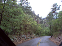
 We have a new favorite place in southern Arizona, Chiricahua National Monument. South of Wilcox, Arizona. The monument is unlike anything we have yet to see in the southwest. There are stands of juniper and pines, streams, deer and lots of birds.
The CCC laid out the paths in this park. I am a big fan of the CCC and am thankful for the wonderful job they did in
 American Parks. What a legacy they left to us!
This area was the site of an ancient volcano eruption that was much like the one on Mount Saint Helen's, but much more violent. The rock formations, called tuffs, are the result of the ancient volcanic activity and the action of erosion.
These r
 ock formations, for lack of a better word, are amazing.
This formation, on the left, is called Organ Pipes, for obvious reasons.
Unfortunately, we picked one of the only rainy days in Southern Arizona to drive out to the park. We thought the rain would be over by mid-morning and we would be able to hike into the wilderness.
It was not to be. So we made the best of things and drove up to Massai Point in the rain. The clouds c
 overed the highest peaks, but we were able to get some good pictures of some of the more spectacular formations.
This area was home to the Apache Indians, and most notably, Cochise. Ft Bowie is nearby. Southern Arizona is one of the most desolate, deserted places I have ever visited, but what a wonderful place to be if you yearn for peace and solitude, and nothing but the sound of birds and the breeze in the junipers.

Chiracahua National Monument has a beautiful campground and is close enough to Tucson that it would be easy to take the camper for a weekend. This park sees relatively few visitors throughout the year, and we enjoy the peace and solitude of having the park all to ourselves.